
Doing the groundwork
Improvements in technology, such as aerial photography, have greatly helped in the diagnosing of subsidence and collection of related data. However, Nigel Barham believes there is still no substitute for doorstep expertise - the personal visit to a claim site to see how the land lies.
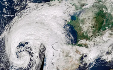
Technological advances such as satellite monitoring and contemporaryaerial photography, if used in conjunction with reliable claims data, may
help to price and manage subsidence risks. As such
Only users who have a paid subscription or are part of a corporate subscription are able to print or copy content.
To access these options, along with all other subscription benefits, please contact info@postonline.co.uk or view our subscription options here: http://subscriptions.postonline.co.uk/subscribe
You are currently unable to print this content. Please contact info@postonline.co.uk to find out more.
You are currently unable to copy this content. Please contact info@postonline.co.uk to find out more.
Copyright Infopro Digital Limited. All rights reserved.
As outlined in our terms and conditions, https://www.infopro-digital.com/terms-and-conditions/subscriptions/ (point 2.4), printing is limited to a single copy.
If you would like to purchase additional rights please email info@postonline.co.uk
Copyright Infopro Digital Limited. All rights reserved.
You may share this content using our article tools. As outlined in our terms and conditions, https://www.infopro-digital.com/terms-and-conditions/subscriptions/ (clause 2.4), an Authorised User may only make one copy of the materials for their own personal use. You must also comply with the restrictions in clause 2.5.
If you would like to purchase additional rights please email info@postonline.co.uk
More on Personal

Ten plead guilty to £320K ‘crash for cash’ fraud
An organised crime group that pocketed more than £320,000 through a ‘crash for cash’ scheme has been caught after multiple insurers raised concerns about claims.
More claims expected from Storm Éowyn after 800% initial spike
Storm Éowyn caused an eightfold increase in claims notifications within an hour of hitting Northern Ireland last week, loss adjuster Crawford has reported.

Fitch expects mixed fortunes for UK non-life insurers in 2025
Fitch Ratings has predicted that the UK non-life insurance sector will have mixed fortunes in 2025, with some parts of the market facing an uphill battle to turn a profit.

Insurance Fraud Bureau investigating 140 fake adverts
The Insurance Fraud Bureau is currently investigating 140 claims linked to paid-advert spoofing activity, collectively worth £1.82m.
Diary of an Insurer: Alps’s Julian Tomlinson
Julian Tomlinson, chairman at Alps, counts his blessings, catches up with plenty of colleagues plus brokers and shares his secrets for a life well lived in the French countryside.

Ignite targeting £50m of home premium per year by 2027
Ignite has told Insurance Post that, following its partnership with Ageas and Yoga, it’s aiming to generate £50m of home premium a year by 2027.

Lessons insurers must learn from LA wildfires
As celebrities condemn insurers after the most destructive wildfire event in Los Angeles County history, Emma Ann Hughes outlines what the industry must do to address the financial and reputational impact of the blaze.

Allianz and LV to merge claims operations
Allianz has started the process to merge the claims operations of both Allianz Commercial and Allianz Personal, which includes LV, Insurance Post can reveal.